Planet Earth - A fossil atoll in central England
The White Peak area of the Peak District National Park is a limestone landscape, with flat plateaus cut by steep-sided valleys or dales.

Map from peakdistrict.gov.uk. Map approx 50 km East-West.
The White Peak is mostly formed from pale grey, thickly-bedded limestones of Carboniferous age deposited between 350 and 325 million years ago.

Photograph of West Quarry from UK Fossils
The limestones form a sequence of strata up to two kilometres thick, although only the uppermost 600m are exposed at the surface.

The rocks were originally deposited in a warm shallow sea, surrounded by much deeper water - very similar to the present day Caribbean.
At this time, the United Kingdom would have been located somewhere near the Equator in tropical latitudes.
Around the edges of the White Peak, the limestone includes massive structures called knolls, which are fossil reefs.
Chrome Hill near Longnor is an example.

The fact these reefs are found around the edge, with flat layers of limestone in the central area, suggests the White Peak was an atoll.
An atoll is a ring-shaped reef.
An atoll surrounds a body of water called a lagoon.
This map shows modern atolls in the Maldives, in the Indian Ocean.

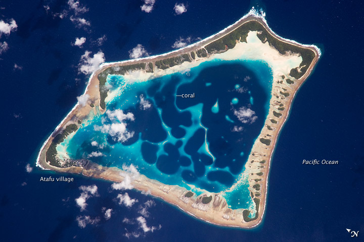
This NASA photograph shows an atoll is in the Pacific Ocean.
The White Peak atoll shows that the area now called 'Britain' was much nearer the equator during the Carboniferous.
Plate tectonics has moved the crust over hundreds of millions of years.
Map from peakdistrict.gov.uk. Map approx 50 km East-West.
The White Peak is mostly formed from pale grey, thickly-bedded limestones of Carboniferous age deposited between 350 and 325 million years ago.
Photograph of West Quarry from UK Fossils
The limestones form a sequence of strata up to two kilometres thick, although only the uppermost 600m are exposed at the surface.
The rocks were originally deposited in a warm shallow sea, surrounded by much deeper water - very similar to the present day Caribbean.
At this time, the United Kingdom would have been located somewhere near the Equator in tropical latitudes.
Around the edges of the White Peak, the limestone includes massive structures called knolls, which are fossil reefs.
Chrome Hill near Longnor is an example.
The fact these reefs are found around the edge, with flat layers of limestone in the central area, suggests the White Peak was an atoll.
An atoll is a ring-shaped reef.
An atoll surrounds a body of water called a lagoon.
This map shows modern atolls in the Maldives, in the Indian Ocean.
This NASA photograph shows an atoll is in the Pacific Ocean.
The White Peak atoll shows that the area now called 'Britain' was much nearer the equator during the Carboniferous.
Plate tectonics has moved the crust over hundreds of millions of years.


